It is not too late to pull off an amazing Easter brunch. The key to a beautiful Easter brunch is to lean on the freshest flavors of the spring season. Here are 10 recipes that will look amazing on your holiday table.
Hash Brown Egg Nests with Avocado: What could be more adorable than these
hash brown egg nests with avocado? Perfectly runny eggs pair with crispy hash browns, bacon, and gooey cheese to create a little nest of goodness. Because of their portability, these nests are a great choice if you are serving a grab-and-go buffet. Feel free to leave out the avocado topping if it does not suit your fancy.
Cinnamon Bun Palmiers: Add an indulgent sweetness to your Easter brunch with these cinnamon bun palmiers. While making classic French pastries may seem intimidating, this cheat version of a palmier could not be any easier. Puff pastry sheets are the cornerstone of the palmiers. The pastry dough is baked in cinnamon sugar and topped with icing made with cream cheese, powdered sugar, milk, and vanilla. The heart-shaped pastries will be a gorgeous centerpiece on your Easter table.
Candied Bacon: Why settle for regular bacon when you can go all out with this candied bacon recipe? All that you need to execute this recipe is bacon, brown sugar, and pepper. Unlike the mess of frying up bacon on the stovetop, this bacon recipe simply bakes in your oven. This makes it easy to set it and forget it so that you can prepare the rest of your meal. Easter is an occasion that necessitates that you kick up your normal routine a notch. This candied bacon certainly fits the bill.
Smoked Salmon Deviled Eggs: No Easter meal is complete without the iconic platter of deviled eggs. This smoked salmon deviled eggs recipe elevates the ho-hum eggs you may be used to eating on this day. The filling includes cream cheese, sour cream, lemon juice, smoked salmon, and mayonnaise to create something truly unique. Top the eggs with some delicate salmon roe and chives for a colorful and flavorful addition. Nobody will miss the traditional deviled eggs when they pop these into their mouths.
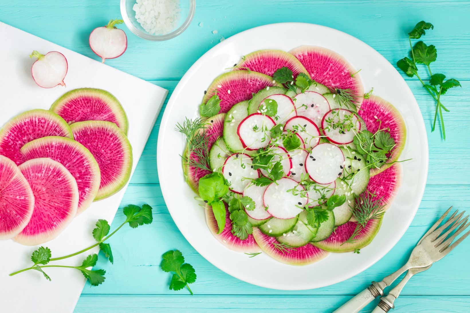
Watermelon Radish and Cucumber Salad: This simple watermelon radish and cucumber salad looks as if you spent hours on it. While watermelon radishes look bland from the outside, you will enjoy a burst of bright fuschia color when you slice them open. Simply layer the radishes with cucumber, microgreens, black lava salt, and a light lemon vinaigrette. Assemble it on a large platter or plate it on small individual plates for an elegant presentation worthy of this special holiday.
Overnight Monkey Bread: If you are going to be tight on time on Easter morning, you will love the convenience of this overnight monkey bread. You can prepare this recipe the night before and simply pop it into the oven in the morning. Kids will love helping to prepare this family favorite. As a bonus, it will make your whole house smell amazing as it bakes in the morning. The sweet glaze is optional.
Ham and Cheese Biscuits: These from-scratch biscuits contain savory ham and cheese to provide more than just a bread dish. The homemade biscuit dough is easier than you think to prepare. Once you have the base, you just fold in the diced ham, shredded cheese, and green onion. You can also prepare these biscuits the week before and freeze them if you know that you will be crunched for time. Serve the biscuits alongside some fluffy scrambled eggs and a bowl of fresh fruit for a complete Easter brunch meal.
Melon and Fresh Herb Salad: Every Easter brunch needs a bowl of fresh fruit that celebrates the freshest tastes of the season. This melon and fresh herb salad is a new take on a classic fruit salad. The addition of the mint and basil completely transforms an ordinary fruit salad. The dressing and herbs work well with a variety of melons, including watermelon, honeydew, and cantaloupe. This light and refreshing salad is a great addition to the heaviness of most classic brunch dishes.
Bloody Mary Bar: Do not forget to add some festive drinks to your Easter brunch. A bloody mary bar will delight your guests because they can create the drink to their liking. Good topping ideas include celery, cornichons, pickles, stuffed olives, pickled asparagus or okra, and jumbo shrimp. The candied bacon recipe also pairs nicely with the bloody mary bar. For something lighter, consider adding a mimosa bar served with a variety of sparkling fruit juices.
Your guests will delight in all of these delicious Easter brunch recipes. Add a festive Easter lily or a vase of colorful tulips to brighten up your table and your feast will be complete.