A
A
A
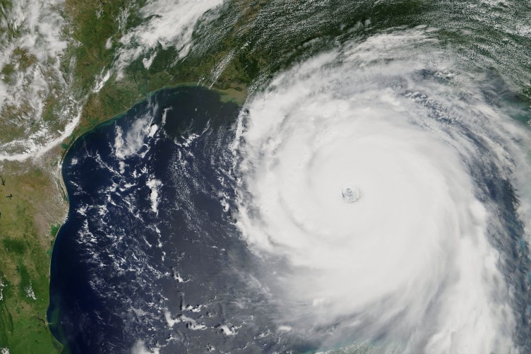
Early on Sunday, August 29, Hurricane Ida clocked 150 mph winds as it neared landfall off Louisiana and 15 mph movement. Although estimated to possibly become a Category 5 hurricane with sustained winds of 156 mph or more, it made landfall in Louisiana at 12:55 p.m. ET as a Category 4 storm that caused structural damage to buildings and widespread flooding. As this is also the anniversary of the devastation caused by Hurricane Katrina in 2005, many Gulf Coast residents still wait with bated breath for updates about Ida’s progress.
How Is Ida Different From Most Storms?
Tropical storms usually take a week or longer to reach Hurricane Ida’s current strength. According to the National Hurricane Center, Ida experienced a rapid intensification of wind force defined by a 35 mph or more jump in a span of up to 24 hours. The NHC noted a 35 mph intensification within only six hours. Meteorologists are still uncertain as to whether Ida might achieve Category 5 strength given past storm patterns, including Katrina’s rapid jump by 55 mph within 18 hours. These types of storms offer people on land little warning or time to reach safe shelters. The wind speeds also cause more damage.
What Causes This Type of Rare Event?
Read More »
High temps in the Atlantic of approximately 86 degrees Fahrenheit and steady upper level winds are two of known causes. Increased ocean temperatures from global warming have caused many experts to believe that an increase in extremely strong hurricanes in recent years are events influenced by human actions. Now that Hurricane Ida is not entirely over warm ocean waters, experts hope that the hurricane’s fierce winds will start to lose their speed. That said, Ida has tied with two other storms, Hurricane Laura and the 1856 Last Island Hurricane, for the strongest Louisiana landfall on record.
Who Is Currently Impacted by Ida?
The Storm Prediction Center has issued a tornado watch in Alabama, Florida, Louisiana and Mississippi until at least 8 p.m. ET. People throughout Louisiana have started evacuation procedures. Those who choose to remain behind in certain areas have been warned that they do so at their own risk. Storm surges and down trees and power lines are especially a concern for anyone near the Alabama, Louisiana and Mississippi coasts. At the time of this publication, more than 77,000 customers of Louisiana’s main energy supplier, Energy Louisiana, are also without power. Many of them have also started to experience flooding. Energy Louisiana has issued a warning that at least 10 percent of its 1.1 million customers might experience loss of power for weeks after this storm passes through the state. The storm has also adversely impacted the oil industry in the Gulf by forcing evacuations at Port Fourchon and delays. Houma in Mississippi is also expected to see potentially 155 mph winds that can adversely impact residents who work in the oil industry. At the national level, Hurricane Ida also threatens to shut down temporarily enough major businesses and supply lines to adversely impact movement of goods across the country.
Does Ida Pose a Super Spreader Risk?
Hurricane Ida poses a tremendous non-water surge risk across the entire southeastern portion of the country as evacuations take place. One of the biggest concerns with Ida’s landfall is the spread of the SARS-CoV-2 virus in states that have already been gravely hit with recent surges in cases, hospital ER visits, ICU bed usage and deaths. Evacuation of these patients is made more difficult by the fact that Delta and its subvariant, Delta Plus, spread far more easily from person-to-person than other variants. Although hospitals have taken precautions, Ida’s rapid winds and uncertain potential to increase to a Category 5 storm have caused some medical experts to worry that evacuating people and patients may spread the virus to other regions where it can cause even more damage and death.
Will Ida Have Katrina’s Fury?
Since 2005, states with coastlines along the Gulf of Mexico have greatly improved their hurricane responses, evacuation procedures and storm surge safety measures. So far, Hurricane Ida has a smaller wind field than Katrina as well, which means that it’s only impacting 50 miles of area from its center as it moves. Katrina’s impact was 90 miles out. That said, Ida’s sustained winds are currently higher. Storm surges are also different. Katrina had Category 5 winds before it made landfall that increased the height of the surges. Meteorologists have made storm surge estimates for Ida that are lower than Katrina. They expect Ida’s surges to only reach 12 to 16 feet or lower depending on the surge region. Katrina’s surges topped 28 feet in some areas. Of course, these are merely estimates. It remains to be seen what final impact Ida has since meteorologists have predicted between 15 to 20 inches of rain, which is expected to cause extensive flooding in the lowlands.
Emergency First Response Alerts
First responders expect to have more difficulties with handling emergency calls, especially with traffic congestion from people trying to evacuate. Because of the rapid intensification of Hurricane Ida, New Orleans hasn’t had enough time to set up contraflow traffic in some areas closest to levees, which means that New Orleans’ mayor has been unable to order a mandatory evacuation. On Saturday, Louisiana Gov. John Bel Edwards told the media that 5,000 National Guard troops were deployed to 14 parishes with boats, helicopters and other equipment capable of search and rescue in high-water zones. An additional 10,000 linemen were placed on standby for power outages. As of early Sunday morning, the United Cajun Navy volunteer search and rescue and disaster relief organization activated all of its state chapters. Louisiana, Mississippi, Alabama, Texas, Florida and Georgia have received 2,400 first responders from FEMA.
This is an ongoing news story with rapidly changing events. More information to come as it is made available.


